My Livingstone Adventure: Part 1 – Mosi-oa-Tunya (Victoria Falls)

It has been a while since my last blog, despite my best intentions. But, hopefully this one is the first of many to follow shortly. This year I achieved one of my life ambitions that I can now cross of my bucket list – I visited the Victoria falls! In the process of visiting the town (one of them, anyway) where the falls are situated I discovered, and experienced, many more adventures, which I will blog about. Here is the first instalment of my Livingstone adventure…

The Zambian tourist town of Livingstone has undergone a major make-over the likes of which it probably has not seen in its history. Town centre and key buildings have received a lick of paint, roads have been patched up and upgraded, grass and flowers have being planted on the road verges, Harry Mwaanga Nkumbula international airport facilities and tourist attractions such as the Livingstone museum and the area around the Mosi-oa-Tunya (the local name for the Victoria Falls, literal translation – ‘the smoke that thunders’) have undergone renovation.

What prompted this transformation? Livingstone is co-hosting the United Nations World Tourism Organisation (UNWTO) General Assembly with Victoria Falls town in Zimbabwe from 24th to 29th August 2013.

And it wasn’t only the town’s infrastructure that was preparing for the UN WTO. The tourism minister bungee jumped in a bid to show Zambians and tourists alike the way to enjoying the activities available to them in this town. Her stated aim was to be able to speak with the authority of one who has themselves experienced and enjoyed the activities.

It was in this atmosphere that I arrived in Livingstone in the middle of August 2013, never having visited the town before, despite growing up in Zambia and having lived there most of my life. At last I could lift the shame that weighed heavily over me, of not being able to speak about the Mosi-oa-Tunya from a position of authority, like the Minister of Tourism, as one who had first-hand experience.

But, it was certainly worth the wait!

Image

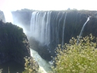
View across the first gorge

While the Zambezi river is not at its fullest at this time of the year, the falls were nevertheless a magnificent sight. I was surprised at the distance they covered, stretching a distance of 1,708 metres (5,604 ft), the full width of the river falling into the first of seven gorges.

The Knife Edge Bridge

The Knife Edge Bridge

Viewing platforms are scattered at strategic points on the cliff opposite the falls, linked by a stone path that takes you on a tour the length of the cliff. Along the way you cross the Knife Edge Bridge, which gives you a spectacular view across the falls and under which the waters of the Zambezi flow from the first to the second gorge.

At the bottom of the second gorge is a 150-metre (500-ft) pool known as the ‘boiling pot’, formed by water entering from the first gorge, reached by a steep footpath. It is calm at low water levels, but becomes a swirling, ‘boiling’ pool when the river is at peak level. I did not get to climb down to see it this time, but it is definitely on the list for my next visit.

The Zimbabwean side of the gorge seen from the Zambian side

The Zimbabwean side of the gorge seen from the Zambian side

At the time I visited, you could walk across the Knife Edge Bridge without getting soaked. However, just after the rainy season, around April/May, the bridge and anyone on it is soaked by the spray coming off the falls. As a colleague of mine who visited the falls in April can testify, the volume and force of the water is such that you get soaked right through even wearing the raincoats handed out at the start of your tour.

So, a tip here is, do not go smartly dressed, unless you do not mind your glad rags getting drenched. Or, alternatively, go later in the year (August to September) when the spray is much reduced and you probably get a better view of the magnitude of the falls from this point, but miss experiencing majesty of the wall of water when the river is at peak level.

Victoria Falls Bridge

Victoria Falls Bridge

Across the second gorge spans the Victoria Falls Bridge, which connects Zambia and Zimbabwe. The bridge is visible from various vantage points on the path winding along the cliff top bordering the Zambezi river. I watched a bungee jumper launch off the bridge towards the gorge below, from the same spot that the Zambian Minister of Tourism had taken the plunge. I was happy to be a spectator rather than a participant!

The edge of the falls

The edge of the falls

Across from the cliff on the river itself, the waters were low enough that you could walk, or swim, in the section that approaches the very brink of the falls. People were swimming and wading in the waters and sitting on outcrops of stone in the middle of the river. I joined in, dipping my toes in the lukewarm water and picking up a pebble to take with me as a souvenir of my visit.

A statue of David Livingstone, after whom the town is named, stands at the point where the two sides of the first gorge meet (Livingstone is probably the only town in Zambia whose name remains unchanged from that given by the colonial rulers, but that is a subject for another blog).

Statue of David Livingstone

Statue of David Livingstone

Livingstone visited the falls on 16 November 1851. According to the plaque at the foot of the statue, on seeing the falls he wrote of his first impression of the falls:

“The most wonderful sight I had witnessed in Africa. No one can imagine the beauty of the view from anything witnessed in England. It had never been seen before by European eyes, but scenes so lovely must have been gazed upon by angels in their flight.”

I couldn’t agree more! No picture can do the incredible views of the falls justice. You have to experience it to appreciate its true beauty and majesty.

Footnote

I visited Livingstone with my sister, two nieces and my mother. We drove from Lusaka to Livingstone.

We stayed at the Fallsview Apartments, off the Airport road, a gated complex of four spacious apartments each with three bedrooms, including a self-contained master bedroom. All rooms are air conditioned with a television receiving terrestrial (local) and satellite channels. There is free Wi-Fi internet access, a swimming pool and braii (barbecue) facilities. Apartments are fully serviced and a chef can be made available for an extra fee.

We also rode an elephant at the Mukuni Big Five Safari, enjoyed a game viewing drive through the Mosi-oa-Tunya National Park and enjoyed a sunset cruise on the Zambezi aboard the African Princess catamaran. We also visited Mukuni village and the Livingstone museum. But these are stories for another blog.

We didn’t walk with the lions or cheetahs, or do the bungee jump, gorge swing, helicopter ride, microlight flight over the falls or white water rafting. These are adventures for another trip – maybe. The Livingstone railway museum sounds more my speed.

Lusaka: A Brief Cultural and Political History

To kick off my Zambia blog, let me take you on a brief cultural and political historical tour of the city in which I grew up Lusaka, the capital city of Zambia.

If you look closely enough, Lusaka‘s, and to a great extent Zambia’s, history is apparent in its monuments, buildings, and roads places like the Freedom Statue, the National Assembly, Mulungushi Hall, the University of Zambia, the National Museum, the Cathedrals and Cairo Road.

Lusaaka village/Manda Hill

Lusaka is spread over a series of hills covering an area of 70 square kilometres, but was originally built on the site of the village named after its headman, Lusaaka. The village of Lusaaka was located near Manda Hill one of the highest hills and which today is in the north-eastern part of the city.

Manda Hill with the National Assembly just visible behind the shopping centre and Great East Rd in the foreground

The National Assembly

Manda Hill is the site of Zambia’s National Assembly building. The building is reachable from Parliament Road, off the Great East Road and houses the country’s Parliament, which opened in 1967. It is one of the first sights visible to the east as you approach the city from the north, a sight worth seeing at night as the copper-clad outer façade of the building is flood-lit and reflects a spectacular orange glow.

Mulungushi Hall

Also located on Manda Hill, and close to the National Assembly, is the Mulungushi International Conference Centre. Mulungushi Hall, as it is popularly know, was built in the record time of four months to host the third Summit Conference of Non-Aligned Nations in September 1970. It is the government’s preferred host site for significant conferences and gatherings.

Its name too has significance in Zambia’s history. The Hall is named after the Mulungushi river, which runs north of the town of Kabwe located in central Zambia. In 1960, a rocky area by the Mulungushi River, which later came to be known as the Mulungushi Rock of Authority, hosted a conference that led to the formation of the United National Independence Party (UNIP) led by Kenneth Kaunda. The party went on to lead the country to independence in 1964.

University of Zambia (UNZA)

UNZA

UNZA Great East Rd Campus

A short distance east of the National Assembly lies the University of Zambia (UNZA), Great East Road campus and the main site of the university. The University also has another campus site, the Ridgeway campus, housing the Medical School and School of Pharmacy, which is located near the University Teaching Hospital south of the city.

UNZA officially opened in 1966 with the

UNZA

UNZA Great East Rd Campus entrance

Ridgeway Campus and with then President, Kenneth Kaunda, as its first Chancellor. The day after his installation, President Kaunda laid the foundation stone for the Great East Road Campus.

Over the years, the student body of UNZA has been at the forefront of protests in support of democracy within the country and in support of other resistance movements in southern Africa, resulting in several closures of the campus over the years.

Cairo Road

Cairo Road

Cairo Road

At its most western point, the Great East Road joins Cairo Road at the roundabout marking its northern extremity. Cairo Road, the main road running through Lusaka city centre, is part of a long highway that runs north to south through several Central African countries. It was part of Cecil Rhodes’ dream to build a highway through Africa stretching from the Cape in South Africa to Cairo in Egypt, and Cairo Road lies along that route, hence its name. Today, the road is a thriving mixture of retail outlets and commercial businesses liberally populated with vibrant throngs of pedestrians and cars.

The Freedon statue

The Freedom statue

The Freedom Statue

Towards the western end of Independence Avenue, which branches off Cairo Road at its southern roundabout, proudly stands the Freedom statue. The sculpture, of a man with arms raised clutching broken chains, symbolises the struggle for freedom from colonial rule and is dedicated to the victims of the struggle for independence. The statue, by British sculptor James Butler, was erected in 1974 during celebrations of  the 10th Anniversary of independence from Great Britain.

Lusaka National Museum

Lusaka National Museum

Lusaka National Museum

Lusaka National  Museum, also on Independence Avenue, is located a stone’sthrow from the Freedom Statue. The exhibits tell the cultural history of Zambia under the sections of ethnography, witchcraft, history and contemporary art.

The ground floor exhibits contemporary work by Zambian artists, while the upper floor displays historical and cultural artefacts, including the witchcraft exhibit an interesting peek into the cultural beliefs that have a strong, if unspoken, influence on the life of the ordinary Zambian.

These traditional beliefs somehow manage to co-exist with the seemingly contradictory imported Western and Eastern religious heritage that are also a firm part of Zambian life and are reflected in Lusaka’s landscape.

The Anglican Cathedral

At the corner of Independence avenue and Chikwa Road is the imposing Anglican Cathedral of the Holy Cross. Built between 1957 and 1962, the foundation-stone was laid by the late Queen mother. The cathedral has often hosted commemorative services and is popular for funerals and weddings.

The Catholic Cathedral

A more recent addition to the landscape and set in the suburb of Longacres is the Catholic Cathedral of the Child Jesus, located at Pope Square (Pope John Paul II celebrated mass at the site when he visited Zambia in 1989 and laid the cornerstone for the cathedral). The cathedral was officially opened in April 2006.

Other Places of Worship

Other Christian denominations are well represented including some long-standing congregations like the Northmead Assemblies of God in Northmead residential area, the Dutch Reformed Church in Kabulonga and many more recent pentecostal and evangelical churches scattered throughout the city.

Other faiths are also represented including the Muslim faith, with several mosques in Lusaka, including Kamwala mosque on Independence avenue, near the town centre. And within shouting distance of the mosque at Kamwala is the Hindu hall, which is the centre of Hindu activities in Lusaka.

This, then is a very brief (and selective) introduction to the history of the city of Lusaka. In subsequent blogs I will be taking a light-hearted look at modern-day Zambia, but highly biased towards life in Lusaka, for obvious reasons. 🙂

I hope you will call back, let me know what you think and add your own observations.

Map of Lusaka

Hello world!

Welcome to my blog. I will be writing about my impressions of life in Zambia in the 21st Century as seen from the eyes of a Zambian living abroad but making  occasional forays home.

Do pop back from time to time and feel free to add your own observations.